Project Summary
This project examined how changing winds along the California coast generate
ocean currents that flow along the coastline. Typically winds blow strongly
southward along California’s coast to produce currents that also flow southward.
These currents form the California Current System and are part of a large, clockwise
circulation pattern in the North Pacific Ocean. Similar currents flowing toward the
equator along the eastern sides of ocean basins occur in the South Pacific, and
Atlantic Oceans. Together they are called eastern boundary current systems.
Most studies of ocean circulation along the California coast have focused on times
when southward winds prevail because these cause deep waters to rise to the
surface near shore in a process called upwelling. Upwelling is very important
because it supplies nutrients to surface waters which in turn support highly
productive ecosystems. These ecosystems benefit society by supporting productive
fisheries. Similar productive fisheries are found in the other eastern boundary
current systems.
But southward winds and upwelling are not the entire story of ecosystems along the
California coast. In this project we focused on times when winds weaken and cause
currents near shore to reverse and flow northward, or poleward. In contrast to
upwelling conditions that bring cooler waters, these poleward-flowing currents
bring warmer waters to nearshore areas. The warm waters accumulate behind
coastal headlands such as the one formed by Point Conception and Point Arguello in
southern California. After winds relax these waters flow around the headland and
move poleward. The Pt. Conception-Pt. Arguello headland is particularly large so the
poleward flows are very strong here. Similar poleward flows occur in the North
Atlantic along the coast of Portugal where the warm waters originate in the Gulf of
Cadiz.
These reversed currents are important because they transport many small marine
animals and their larvae northward along the coast. As they travel, many of these
animals find suitable habitats on shallow reefs or closer to shore in tide pools and
estuaries. They remain behind after southward winds and currents return. In this
way reversed coastal currents bring southern species northward along the
California coast to support the diversity of coastal marine ecosystems found here.
A goal of our project was to measure the size of these flows, to learn how they
propagate, and to determine the flow patterns they produce. An interesting feature
of these flows occurs near shore. On the inner part of the poleward currents, there is
often well-defined front end or “nose” that moves along the coast at about a walking
pace, typically 10 to 30 kilometers (6-19 miles) per day. This is unlike most ocean
currents that are continuous with no clearly defined front end. On a human scale the
poleward currents are large. They extend offshore up to 30 kilometers offshore (18
miles) and can be hundreds of kilometers long as they move northward along the
California coast.
In the nose regions of these currents, seawater flows toward coastline in wide
curving arcs. The seawater in the currents brought to the coastline is noticeably
warmer than the waters they displace, up to 4 °C (7 °F). If you were swimming in the
ocean, say off a beach on the central California coast, during the arrival of one of
these flows would notice such a large temperature increase. You might also notice
yourself being gently pushed toward the shore.
The large headland formed by Points Conception and Arguello that was the center of
our study area is shown in Figure 1. The headland shifts the orientation of the
coastline from roughly north-south to east-west. When upwelling winds prevail,
warm water is found to the east and south of Pt. Conception in an area called the
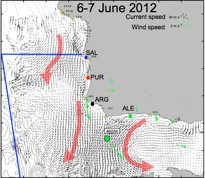
Southern California Bight. Figure 2 shows the pattern of surface currents during 5-9
June 2012 (black arrows) when strong, upwelling winds were blowing toward the
southeast along the coast (red arrows). This is a typical summertime current
pattern in the region. Water temperatures were cold along the coast north of Pt.
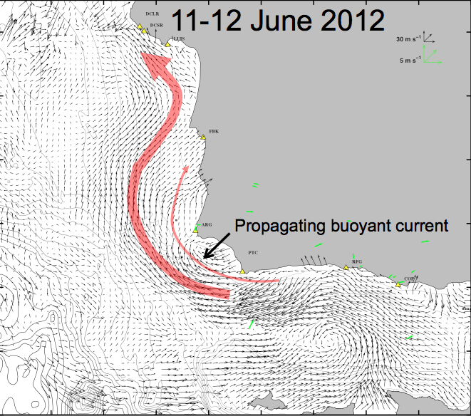
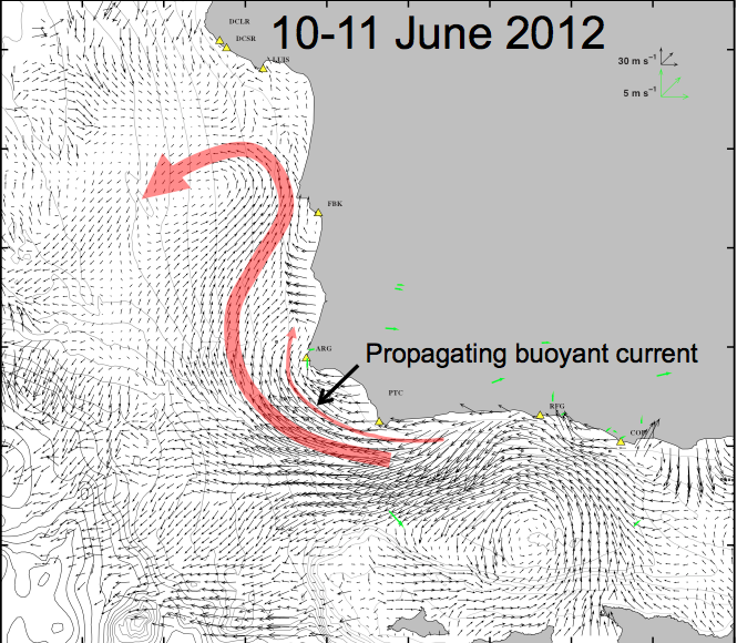
Arguello, about 10 °C (50 °F). Figure 3 shows currents a few days later when winds
relaxed during 10-11 June. Current patterns shifted dramatically. Southward
currents near Pt. Conception and Pt. Arguello now turned westward and northward
as they flowed up the central California coast. The surface current patterns of
Figures 2 and 3 were observed using a network of oceanographic radars (small
yellow triangles). We observed many such changes in current patterns during our
study.
We also studied the pattern of changing atmospheric conditions that give rise to
wind relaxations. To do this we used winds measured from NOAA meteorological
buoys and from satellites. The wind relaxations observed in our study area are part
of a very large atmospheric pattern that evolves over about a 10-day period along
the west coast of the U.S.
Figure captions:

Figure 1. Study area near Point Conception, California
The study area was centered along the south-central California coast on the
headland of Pt. Conception and Pt. Arguello. The area encompassed the Santa
Barbara Channel and the Northern Channel Islands. The Pacific Ocean lies to the
west and the greater Southern California Bight lies to the east and south.

Figure 2. Surface currents during strong winds
Surface currents in the study area during 5-9 June 2012 when strong winds
prevailed. Currents north off Pt. Arguello and Pt. Conception flowed southward.
Some of the flow near recirculated back into the Santa Barbara Channel along the
coasts of the islands. Currents were measured from oceanographic radars (small
yellow triangles along the coast).

Figure 3. Surface currents during a wind relaxation
Surface currents in the study area during 10-11 June 2012 during a wind relaxation.
In contrast to Figure 1, currents north off Pt. Arguello and Pt. Conception flowed
westward and northward. A counter-clockwise flowing eddy was also present in the
channel.
Conclusions & future directions
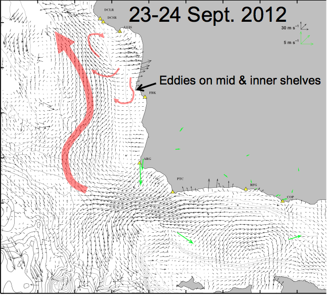
1. Strong poleward pressure gradients force poleward jet-like flows upwind along the California coast north of Pt. Conception.
2. The poleward jets extend to the seafloor over the mid-shelf (100 m depth).
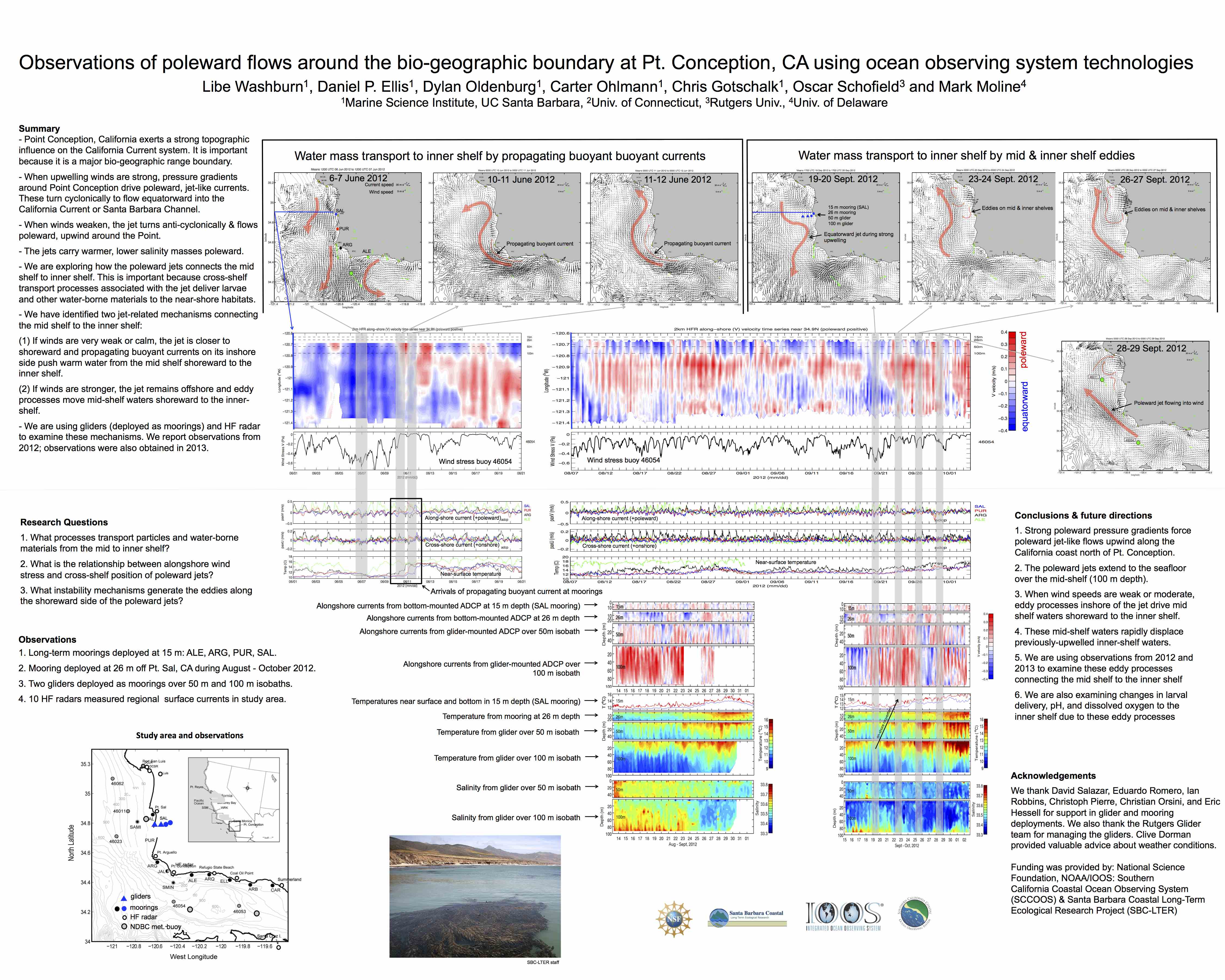
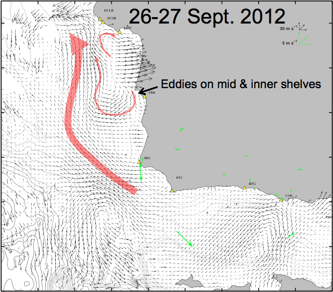
3. When wind speeds are weak or moderate, eddy processes inshore of the jet drive mid shelf waters shoreward to the inner shelf.
4. These mid-shelf waters rapidly displace previously-upwelled inner-shelf waters.
5. We are using observations from 2012 and 2013 to examine these eddy processes connecting the mid shelf to the inner shelf
6. We are also examining changes in larval delivery, pH, and dissolved oxygen to the inner shelf due to these eddy processes
Acknowledgements
We thank David Salazar, Eduardo Romero, Ian Robbins, Christoph Pierre, Christian Orsini, and Eric Hessell for support in glider and mooring deployments. We also thank the Rutgers Glider team for managing the gliders. Clive Dorman provided valuable advice about weather conditions.
Funding was provided by: National Science Foundation, NOAA/IOOS: Southern
California Coastal Ocean Observing System (SCCOOS) & Santa Barbara Coastal Long-Term Ecological Research Project (SBC-LTER)
Data: